The City of Cape Town is planning to rid select streets in its Central Business District (CBD) of cars in favour of cyclists and pedestrians.
The City recently published its latest draft local spatial development framework containing a so-called “Mobility and Access Plan” (MAP) specifically designed for the CBD.
According to Cape Town authorities, the Mobility and Access Plan seeks to optimise the use of existing transport infrastructure to enable many more people to move around the CBD.
“It proposes some bold interventions to make the CBD more pedestrian friendly and to improve access to and within the area,” said the City’s Mayoral Committee Member for Urban Mobility, Councillor Rob Quintas.
The intention is to create a walking and cycling network that is efficient and well-connected; and one that users find safe and convenient.
“Ultimately, those who work and live in the CBD, and visitors, must find it easy to get to their destinations and a pleasure to move through the area,” said Quintas.
He explains that the main ideas are to improve walkability in the heart of the CBD, especially around public transport stations.
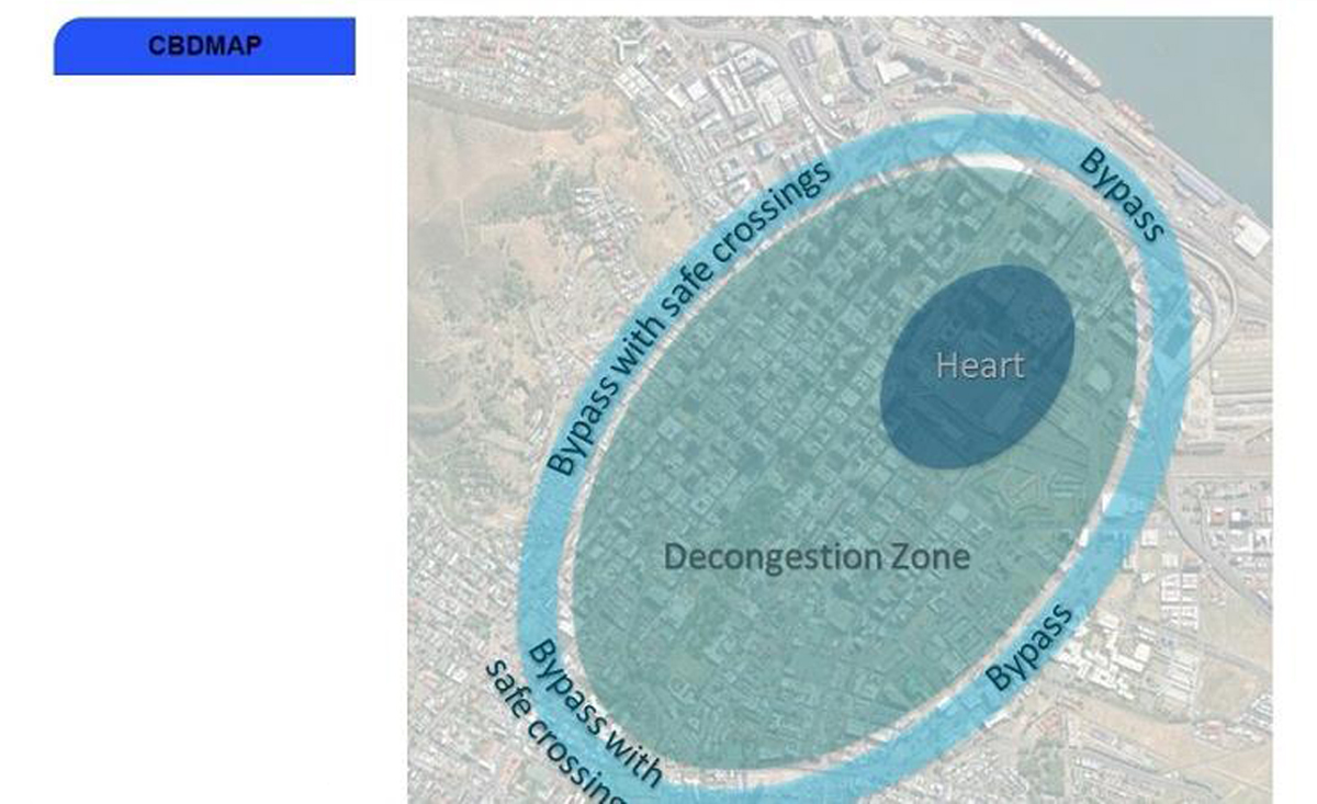
To achieve this, the City wants to create a large decongestion zone and divert traffic onto bypass roads with targeted safe crossings for pedestrians and cyclists.
“The decongestion zone would include superblocks, similar to those in Barcelona, but relevant to the local context,” said Quintas.
The Barcelona superblocks were designed to reallocate public spaces once used by vehicular traffic for pedestrians and cyclists to improve residents’ quality of life.
A study by the health institute BCNecologia Barcelona showed that the life expectancy of residents living in and around superblocks stand to increase by almost 200 days.
In addition, the reduction in emissions leads to fewer “heat islands” – and could prevent around 300 premature deaths per year.
Business also boomed around these superblocks, with the number of stores rising by as much as 30% between 2017 and 2021, according to Barcelona.de.
Barcelona currently has a population of around 1.7 million people, while Cape Town had just shy of 4.8 million residents according to the 2022 census.
Judging by these figures, a car-free Cape Town CBD could be tremendously beneficial for the Mother City and its many inhabitants.
A car-free Cape Town
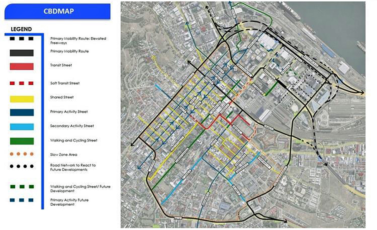
The objectives of the MAP encompasses the prioritisation of public transport along transit streets including Darling and Adderley Streets, as well as related street sections.
It also aims to re-prioritise lower-order streets from vehicular traffic to pedestrian-friendly spaces to encourage walking and dwelling.
Moreover, the City intends to support internal economic growth and social activity along what it calls “activity streets” – such as Bree, Long, and Loop Streets.
The majority of vehicular movement will therefore be relegated to high-order bypass routes.
These include Buitengracht, Buitensingel, Mill, Tenant, and Christiaan Barnard Streets, and the Foreshore Freeway precinct.
“Thus, the plan proposes a road network plan that identifies the role, function, and typical characteristics of the roads within the CBD study area,” said Quintas.
It also suggests a schedule of routes to be partially pedestrianised.
“The intention is for the majority of vehicular traffic to travel around the CBD with no parking or cycling along these bypass routes,” said Quintas.
The plan further identifies routes where public transport will be given priority.
It proposes reallocating the street space to reflect the priorities of pedestrians, in particular for commuters using public transport, cyclists, and activities supporting economic activity.
The City also intends to develop a parking plan for the CBD to facilitate a gradual transition from private vehicle dominance towards a more people-centred environment.
The parking plan will elaborate on the provision of park-and-ride facilities on the periphery of the CBD to ensure the area becomes as car-free as possible.
Another key priority is to develop an integrated transport and land-use solution for the Foreshore Precinct.
The current freeway viaducts carry massive amounts of traffic during the morning and afternoon peak periods, leading to extreme congestion in the area.
“The scoping study is aimed at developing the optimum transport and land use solution to ensure long-term investment and economic growth of the Central City and Atlantic Seaboard, while maximising the precinct’s public amenity value and development potential,” said Quintas.
One suggestion put forth by Gareth Ramsay, a development engineer at Cape Town-based S-Plane Automation, is to build an elevated railway in the Foreshore Freeway precinct.
The “Sky Train” would also have light-rail lines that branch off from the main railway to take passengers into the city at street level.
“The primary objective as it relates to pedestrians and cyclists is to, ideally, arrive at a ‘car-free’ CBD,” concluded Quintas.
The metro has invited the public to submit their comments on the MAP by or before 11 May 2025.
This can be done online or during the various public information sessions hosted by the metro.